We hope to see you at the fair this summer. This is where we plan to set up our museum-like displays and have some great conversations:
July 19-23
Dane County Fair
Waukesha County Fair
August 3-13
Wisconsin State Fair
We will be in a new location this year. Our location is the Central Marketplace near the Bank Mutual Stage.
August 31-Sept 4
Sheboygan County Fair
Tuesday, July 11, 2017
Sunday, April 30, 2017
The Wonders of Wisconsin- Creation and Biblical Flood Hike- Parfrey's Glen and Devil's Lake area


 The Sauk megasequence is named after Sauk county and is seen
worldwide from the Grand Canyon, to Wisconsin, to the Middle East, to
Africa. The Parfrey’s Glen formation is made up of sandstone which
is the same as the Tapeats sandstone in the Grand Canyon.
The Sauk megasequence is named after Sauk county and is seen
worldwide from the Grand Canyon, to Wisconsin, to the Middle East, to
Africa. The Parfrey’s Glen formation is made up of sandstone which
is the same as the Tapeats sandstone in the Grand Canyon.The hill behind the glen is made of the same Baraboo quartzite at Devil's lake but is only visible at a small outcropping. You can see the 25 degree angle consistent with the Baraboo bowl shaped syncline.
Remaining in the glen are several igneous rhyolite and granite erratics. These rocks are not native to this area but were transported by the glacier all the way from northern Wisconsin or Canada.
Since the Baraboo quartzite is from the creation week, then the Parfrey’s Glen conglomerate sandstone would have been the first layer deposited in the worldwide Food. This sandstone covers the bedrock and is a conglomerate consisting of rocks and boulders of Baraboo quartzite. During the flood other layers (Mt. Simon formation, Eau Claire formation, etc.) intersected the Parfrey’s Glen formation which lies on the sloping syncline of the Baraboo formation. Since Parfrey’s Glen conglomerate is found uniformly from the bottom of the bluff to the top, the same environmental conditions (the Flood) must have been in place while the entire bluff was being buried. Just a few hundred feet to the south and southeast, the Parfrey’s Glen formation intertongues with the rest of the Sauk megasequence layers which are horizontal. According to evolutionsists, these horizontal layers were formed over a period of 128 million years each under different environmental conditions including deep and shallow seas, beaches, and dry land. Obviously environments this different cannot exist within a few hundred feet of each other over millions of years. The most straightforward explanation is that all of the rock was deposited over a short period of time under flood conditions.
Since Wisconsin sits on top of the granite continent, and the granite floats above the basalt ocean basin, then Wisconsin could never have been under an ancient ocean. All the sand (and cementing material to make sandstone) in Wisconsin had to be transported here from the coastlines. Being located at almost a center-point between the Pacific, Arctic, and Atlantic oceans the Flood water currents would have been coming from all directions carrying sand and silica from various sources.
The flood waters deposited all the sedimentary layers we see today, but they also deposited over 325 ft. of additional sedimentary layers which eroded at the end of the Flood. The release of this overburden caused orthogonal fractures (cracks at right angles) in the underlying rocks. Looking from above you can see that all the dells, glens, and the Wisconsin River follow right angle patterns that started as fractures which runoff water eroded into larger waterways. The erosion of the glen probably started with the Flood, but runoff and ruptures of glacial lakes widened the glen to what we see today.
Rapid water flow also carved potholes in the glen riverbed. As the riverbed eroded some of these potholes remained up on the walls of the glen.
As the glaciers melted, the under cutting of the sandstone caused large boulders to fall at the end of the glen. The flash flood of 2008 destroyed what used to be the scenic overlook at the end by the same undercutting process.


 |
| Look straight up from Melissa's head. There you can see some of the conglomerate layers in the sandstone. Lee explains:
Parfrey’s Glen is the type site for the Parfrey’s Glen Formation, a formation that has outcroppings all around the Baraboo Bluffs. As we hiked the trail, looking straight ahead at the base of the hill the first time we forded the creek, we saw quartzite bedrock at about a 25 degree angle from horizontal confirming the fact that the quartzite has been folded. Once we climbed the first set of rock stairs and entered the narrow portion of the Glen, the quartzite bedrock cliff is buried several hundred feet west of the sandstone conglomerate that you have pictured. The only quartzite that you see in the narrow gorge are the pebbles and boulders of quartzite that had been broken off of the bluff by flood waters and cemented in a sand matrix. Unlike any other rock layer in the area, the Parfrey’s Glen Formation is a near vertical layer and was placed that way in situ up the face of the quartzite cliff. No matter what the geological “period” being studied, this formation remains the same and is therefore good evidence for deposition by an ongoing catastrophe of much shorter duration than evolutionists assume. If that were not the case, we would expect to see the conglomerate matrix to shift from sand to silt and then lime as the layers next to them did. But that is not what we find. The layers of sand, pebbles, rocks, and boulders were sorted by wave action and currents which changed constantly throughout the flood. While the Glen was glaciated, it was near the farthest reach of the glacier (terminal moraine). Therefore, this area endured the glacial abrasion for a shorter time frame and was not scoured clean. The glacier’s progress was also being impeded by its climb up the very hard quartzite bluff. It is difficult to say exactly how the Glen was formed but was likely a combination of receding flood waters cutting a channel through the Parfrey’s Glen Formation next to the resistant quartzite bluff and a deepening of that gorge by glacial meltwater later on. There was no dam breach erosion here as occurred in the Dells area.
|
 |
 |
Ripples form in sand from waves or
water flowing. The top layer of sand could have developed ripples
while underwater, and the catastrophic movement upward on day 3
instantly metamorphosed those ripples into quartz.
|


 |
Quartz
in its pure form is just silicon dioxide (SiO2). Liquid silicon
dioxide is clear (like glass). The red color in the Baraboo quartzite
is from varying amounts of iron mixed in the silicon dioxide. The
layering of sand is evident in cross sections, and shows signs of
moving water before God moved it to emerge above the surface. Each
crossbed layer (horizontal layer with diagonal lines through it) was
formed when fast-flowing water built sand waves that were originally
twice as high as the resulting rock layer.
The
twisted structure seen in some quartzite forms in sandstone when an
earthquake shakes the sand underwater on a slope.
The
Baraboo quartzite forms a bowl around the city of Baraboo. This bowl
shape formed as the center depressed and the edges arose. This
bending of the rock left slickensides on the horizontal planes
between layers. These slickensides must have formed while the rock
was warm enough not to fracture, but cool enough to leave evidence.
|

Quartzite
is a common metamorphic rock on the Earth, but it only appears at the
surface in a few places because it is usually very deep. The Baraboo
quartzite is one of the few places in the world where scientists can
study a quartzite formation.
It is impossible to measure the age of a rock. Several techniques have been developed to measure the elements in rock and use assumptions to determine the rock ages. The granite intrusions in the Baraboo quartzite were uranium-lead dated to be between 1.64 to 1.76 billion years old; however, helium diffusion rates of the same rock yields rock ages of 6,000 years old. Since raidometric dating methods are built on assumptions there is no way to know if a date is correct because it is impossible to go back in time to verify if the assumptions are true. The only way we can know what is true is if we follow the words of someone who was there and cannot lie. While the Bible is not a science book it never contradicts science, and science always confirms the Bible is true.
The Baraboo quartzite appears to have formed during the creation week because it is a basement rock and contains no fossils. Just by looking at a rock it is not possible to tell if a rock was created in the beginning or if it formed later, but since we know there was no death before sin we can know a rock was not formed during the creation week if it:
It is impossible to measure the age of a rock. Several techniques have been developed to measure the elements in rock and use assumptions to determine the rock ages. The granite intrusions in the Baraboo quartzite were uranium-lead dated to be between 1.64 to 1.76 billion years old; however, helium diffusion rates of the same rock yields rock ages of 6,000 years old. Since raidometric dating methods are built on assumptions there is no way to know if a date is correct because it is impossible to go back in time to verify if the assumptions are true. The only way we can know what is true is if we follow the words of someone who was there and cannot lie. While the Bible is not a science book it never contradicts science, and science always confirms the Bible is true.
The Baraboo quartzite appears to have formed during the creation week because it is a basement rock and contains no fossils. Just by looking at a rock it is not possible to tell if a rock was created in the beginning or if it formed later, but since we know there was no death before sin we can know a rock was not formed during the creation week if it:
1.Contains
fossils.
2.Is
on top of layers containing fossils.
On
day 3 of the creation week God said, “Let the dry land appear.”
And it was so. It does not look like this was an instantaneous
process, but like the rest of the creation God used supernatural
movement of natural processes (during the span of one 24 hour day) to
create the land. At the beginning of day 3 the sediment that makes up
the Baraboo quartzite was below the surface of the water. As God
moved the land to the surface the heat metamorphosed
the sand into quartzite


 |
"Mysterious" potholes at
Devil's Lake State Park, WI |
At Devil's Lake you find potholes that were carved from swirling water. The potholes occur on the inside corner of a river bend when a course rock (chert) settled in a depression and were spun by the water moving past. The mystery for long age geology is how a river was flowing 500 ft. above the ground level! These potholes must have formed from the worldwide Flood waters as they were leaving the continent because at no other point in history was the water level that high.
Wisconsin is dome shaped with the peak
of the dome in northern Wisconsin. At the end of the Flood sheet
erosion removed almost all of the sedimentary rock in northern
Wisconsin while leaving sedimentary layers in the south and at the
east coast.
At the height of the Flood there was as
much as 325 ft. of sedimentary rock above the top of the Devil's Lake bluffs. These sedimentary layers
can still be seen in other places in Wisconsin like Blue Mound.

Though full of debris from the winter, you can still see the pothole formations in the very hard quartzite. The runoff from the Biblical Flood gives a very solid explanation for their formation. Secular geologist call them "mysterious", but Christians have the Biblical text that gives understanding to the past.
 |
| "Mysterious" pothole |
Some examples of Wisconsin geology:
- Before the fold up of the Rocky and Appalachian mountains, northern Wisconsin was a high point on the continent. The sheet erosion event at the middle to late Flood exposed the igneous and metamorphic rocks that were created during the creation week.
- The Flood sedimentary layers that were not removed contain many amazing fossils like jellyfish and trilobites that can be found in quarries throughout the state. While much of the flood was violent and deposited conglomerates with huge boulders, the preserved jellyfish and sand ripples indicate the Flood ebbed and flowed between catastrophic and gentle.
- The glaciers came through Wisconsin leaving much evidence in lateral moraines, terminal moraines, till, erratics, drumlins, scraped rock, and kettle lakes. The moraines we see today are probably what was dropped at the end of the Ice Age. Each year the glaciers expanded and retreated with the seasons, reaching their climax about 500 years after the Flood.
- The south and west part of Wisconsin is covered with the Driftless Area. This is a part of the state that was not glaciated but was catastrophically eroded. Highway road cuts clearly show horizontal layers deposited by the Flood, but the uneven erosion indicates catastrophic water flow.
- Large amounts of water flowing through soft, easily dissolved limestone allowed for the formation of caves across Wisconsin.
- Wisconsin is surrounded by two of the largest bodies of fresh water on the planet that provide beaches, islands and bluffs. Walking along the shore you can easily find fossiliferous rocks containing various corals.
- The subcontinental divide runs through Wisconsin. The southern and western part of the state drain through the Mississippi River out to the Gulf of Mexico, while the northern and eastern part of the state drain out the Great Lakes through the St. Lawrence sea way to the Atlantic Ocean.
The items presented here is a summary of data from multiple researchers, interpreted with the Bible as our starting point. The creationist model of geology changes as new facts emerge; however, the current model explains everything we see.


Thursday, April 27, 2017
Bullied at the West Bend Community Memorial Library
What's
the Evidence? put up a beautiful fossil display at our local public
library last week. Over the years we have collected some pretty neat
fossils found worldwide, and in our fair booths we display them
without shame as evidence for the Biblical Flood recorded in Genesis.
I tweaked our posters to make them more friendly to the library
patrons. In other words , the facts of fossils were spelled out, and
The Flood evidences mentioned, but the Biblical references were mild,
as you can see in the pictures.
Despite
the display being impressive, yesterday, after the display being up
less than a week, I received this email from one of the
librarians: Hi Mary,
Our director has asked me to ask you if you would just take out
the display in the bottom right corner with the Bible quote on it, as
our policy states that we cannot have displays that do this:
"Religious
or political materials which have the primary purpose to effect or
proselytize for a single point of view." You can read
it on our policy page. There have been a few complaints about
it. She didn't really want you to have to take that out, but it
is a board policy - maybe I'll just take out your little business
card too and keep it on my cart in case anyone is interested?
I
emailed her back asking that she not remove anything until I speak
with an attorney. She immediately wrote back assuring me that she
would not take any of my display down until I contacted her. I then
alerted an attorney from Liberty Counsel. He began to look into the
issue and let me know that their policy is unenforceable given
their practice and the law.
This morning the librarian called me back and told me she talked with the director and board president and they determined I did not need to remove or cover any part of my display! Just the idea I was communicating with an attorney made them think twice about squashing my free speech.
This morning the librarian called me back and told me she talked with the director and board president and they determined I did not need to remove or cover any part of my display! Just the idea I was communicating with an attorney made them think twice about squashing my free speech.


The library is now going to revisit their display case
policy. I believe it is important to advoate for this, among other
things, language to be included in the policy: "In
carrying out this policy, library staff shall not engage in viewpoint
discrimination on the basis of religious or secular viewpoint."
Amy
Becker – Director abecker@west-bendlibrary.org
Update: 4/27/17 1650 pm
Through an open records request I found that one patron complained about the display being religious proselytizing. The teen service librarian then took photos of the display and emailed Amy Becker, the director, who then requested I alter my display and take down the Bible verses and the card that identified What's the Evidence? as the sponsor of the booth.
Saturday, December 17, 2016
More evidence for recent fossilization of animals
Fossil Feather Proteins Confirm Recent Flood
by Tim Clarey, Ph.D. *
Ever since Dr. Mary Schweitzer's 20051 discovery of preserved original dinosaur proteins and blood cells, many secular scientists have remained skeptical. How could dinosaur fossils retain original organic material after millions of years? A new ancient bird fossil reveals more unexpected original chemicals, adding fuel to the fierce debate within the scientific community.2
Following publication of her original paper,1 some of Schweitzer's critics claimed that what she actually found was contamination from lab analysis or contamination during field collection. Others claimed these proteins were really from modern bacterial activity, and they merely simulated original soft tissues.3
In response, Dr. Schweitzer and her colleagues performed more studies on the soft tissues in question.4,5They even extracted collagen from a tyrannosaur leg bone and found a protein match of about 58% with bird collagen and 51% with frog and newt collagen—evidence these samples couldn't be from contamination. In further support that these are real dinosaur organic tissues, another study examined 89 amino acids extracted from a T. rex specimen, finding perfect matches with some modern animal proteins. Schweitzer's team has essentially demonstrated the "impossible." These dinosaur soft tissues are real.
Image credit: Copyright © 2016 X. Wang. Adapted for use in accordance with federal copyright (fair use doctrine) law. Usage by ICR does not imply endorsement of copyright holders.
*Dr. Clarey is Research Associate at the Institute for Creation Research.
Article posted on December 12, 2016.
Article from; ICR.org
Thursday, November 10, 2016
Grand Canyon Fun!
In October we were thrilled to take part in a rim tour and Colorado River float of the Grand Canyon with Russ Miller of Creation Ministries and Jay Seegert of The Starting Point Project. Russ stressed over and over again the significance of Red Butte, just south of Grand Canyon. ICR wrote a short article highlighting this significance. Enjoy!
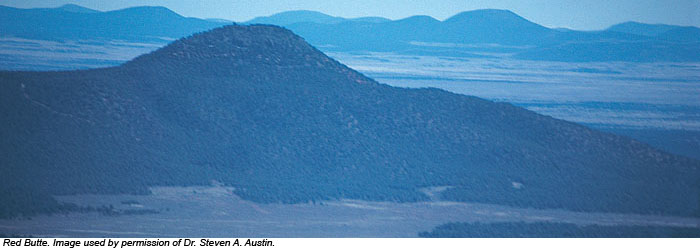
Red Butte: Remnant of the Flood
by William A. Hoesch, M.S. *
Sixteen miles from Grand Canyon's south rim, a cone-shaped butte rises like a lone sentinel 1,000 feet above the Coconino Plateau floor. Thousands of tourists rush past on Arizona Highway 64 without giving it another thought, yet this humble little hill testifies to a remarkable past.
Red Butte is composed of flat-lying shales of the Moenkopi Formation, overlain by Shinarump Conglomerate of the Chinle Formation. Continuous exposures of these two formations are not found for tens of miles around, yet they occur here. These strata sit on a foundation of flat-lying and resistant Kaibab Limestone, the rim rock for most of Grand Canyon and surface of the Coconino Plateau. A basalt (lava) flow tops the butte, protecting the softer layers below from erosion. Lava ordinarily flows downhill, so how did it get on top? Answer: it flowed onto a surface that was once 1,000 feet higher than the present Coconino Plateau! Strata of the Moenkopi, Chinle, and perhaps other formations were stripped away by erosion. Red Butte stands as the most prominent vestige of this once continuous layer.
* Mr. Hoesch is Research Assistant in Geology.
Cite this article: Hoesch, W. 2008. Red Butte: Remnant of the Flood. Acts & Facts. 37 (3): 14.
Sunday, October 30, 2016
Some short, fun and informative video clips
Check out our YouTube page and see some awesome videos on a variety of topics. This one is on the topic of sharp teeth:VIDEO CLIP
Monday, September 12, 2016
Dinosaur Fossils in These Rock Layers?
Cite this article: Tim Clarey, Ph.D. 2015. Dinosaur Fossils in Late-Flood Rocks. Acts & Facts. 44 (2).
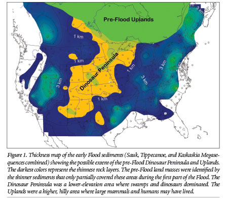 Deposition of the earliest Flood sediments (the Sauk, Tippecanoe, and Kaskaskia Megasequences) was thickest in the eastern half of the U.S.—often deeper than two miles! In contrast, the early Flood deposits across much of the West are commonly less than a few hundred yards deep, and in many places there was no deposition at all (Figure 1).
Dinosaur Fossils in Late-Flood Rocks
by Tim Clarey, Ph.D. *
Evolutionary scientists view Earth’s rock layers as a chronological record of millions of years of successive sedimentary deposits. Creation scientists, on the other hand, see them as a record of the geological work accomplished during the great Flood’s year-long destruction of the Earth’s surface. If that is the case, though, why don’t we find dinosaur fossils in the earliest North American Flood sediment layers—why do we find them only in later Flood rocks? The ICR team’s recent examination of sedimentary rock layers across the United States and Canada seems to provide an answer.
Deposition of the earliest Flood sediments (the Sauk, Tippecanoe, and Kaskaskia Megasequences) was thickest in the eastern half of the U.S.—often deeper than two miles! In contrast, the early Flood deposits across much of the West are commonly less than a few hundred yards deep, and in many places there was no deposition at all (Figure 1).
* Dr. Clarey is Research Associate at the Institute for Creation Research and received his Ph.D. in geology from Western Michigan University.
Cite this article: Tim Clarey, Ph.D. 2015. Dinosaur Fossils in Late-Flood Rocks. Acts & Facts. 44 (2).
Friday, August 5, 2016
Old Evolutionary Icon Still Being Exposed
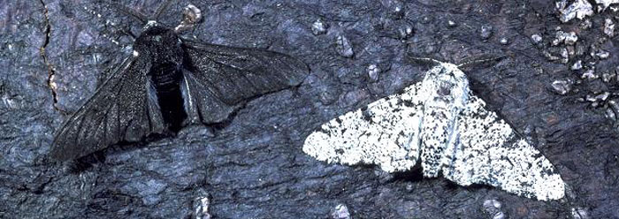
Peppered Moth Still Not Evolving
by Brian Thomas, M.S. *
http://www.icr.org/article/9485
Back in 2003, ICR founder Dr. Henry Morris explained a few ways evolutionists themselves criticized the use of the peppered moth as an example of evolutionary beliefs.1 New genetic research validates those criticisms.
The moth earned fame as a key player in a classic evolutionary story in the late 19th century. In England, a population of peppered moths supposedly shifted their coloring from mostly white to mostly black after soot from the industrial revolution darkened their tree-trunk homes. According to the tale, bird predators had a difficult time seeing the now-camouflaged dark moths, so those moths began to thrive.
That story helped rescue Darwin's conception of natural selection from a round of early 20th century criticisms, such as a lack of supporting field evidence.
However, later researchers could not replicate the peppered moth results. Other investigators discovered that most of the story's facts were essentially wrong. For example, peppered moths live mostly beneath leaves, not on tree trunks. One researcher staged photos of the moths on sooty trunks—not where moths naturally rest.
Image credit: © 2011. M. Henderson. Adapted for use in accordance with federal copyright (fair use doctrine) law. Usage by ICR does not imply endorsement of copyright holders.
*Mr. Thomas is Science Writer at the Institute for Creation Research.
Article posted on August 4, 2016.
Monday, July 25, 2016
2016 fairs so far
Non-stop. That describes the activity at the Dane County Fair yesterday. Great conversations, sharing evidences, sharing Christ, answering questions, talking about the Flood, fossils, creation, God's Word. Wow, Three of us were so busy reaching out. It was a great day. I heard the booth in Waukesha was also busy, plus they received an award for their booth! Enjoy the pictures and keep praying for folks who come to the booth as well as the workers. We are only half way through fair season! To God be the glory.


 |
| Best Forum Vendor at Waukesha County Fair 2016 |
 |
| Ryan was such a blessing and help! |

 |
| Discussion about the "Races" of mankind. |

Thursday, July 21, 2016
I Love Lucy?
by William A. Hoesch, M.S.* http://www.icr.org/i/pdf/btg/btg-211.pdf
Lucy, to TV audiences of the 1950s and 1960s, was a spunky red-headed actress. To our more educated schoolchildren today, however, “Lucy” means somethingquite different. She is the celebrated fossil that appears in textbooks as a hairy, seminaked, upright-walking ape striding boldly across a treeless African landscape. Her jaw is set and she leaves behind her a set of trailing footprints. As the unquestioned icon of human evolution, her fame is comparable to that of the former actress. Why is it that all public school children have heard of this fossil? Let us consider Lucy and her species, Australopithicus afarensis. The human evolution story usually begins with the more primitive australopithocines (literally, “southern apes”) that transition into the genus Homo (or human), through either Homo habilis or Homo erectus, depending on who you talk to. Homo habilis is a mixed taxon of both human and ape remains, and has fallen into disrepute. As for Homo erectus, a great many suggest this category be subsumed into Homo sapiens. Thus “Lucy” and the afarensis fossils occupy a critical place in the human evolution story, squarely between that of the truly apish australopithocines and humans. Lucy’s skeleton was about 40% complete and was a remarkable discovery when unearthed by Don Johanson in 1974.
Lucy, to TV audiences of the 1950s and 1960s, was a spunky red-headed actress. To our more educated schoolchildren today, however, “Lucy” means somethingquite different. She is the celebrated fossil that appears in textbooks as a hairy, seminaked, upright-walking ape striding boldly across a treeless African landscape. Her jaw is set and she leaves behind her a set of trailing footprints. As the unquestioned icon of human evolution, her fame is comparable to that of the former actress. Why is it that all public school children have heard of this fossil? Let us consider Lucy and her species, Australopithicus afarensis. The human evolution story usually begins with the more primitive australopithocines (literally, “southern apes”) that transition into the genus Homo (or human), through either Homo habilis or Homo erectus, depending on who you talk to. Homo habilis is a mixed taxon of both human and ape remains, and has fallen into disrepute. As for Homo erectus, a great many suggest this category be subsumed into Homo sapiens. Thus “Lucy” and the afarensis fossils occupy a critical place in the human evolution story, squarely between that of the truly apish australopithocines and humans. Lucy’s skeleton was about 40% complete and was a remarkable discovery when unearthed by Don Johanson in 1974.
Subscribe to:
Posts (Atom)